School + Transit Design Research Workshop
In 2016, the Georgia Conservancy's Sustainable Growth Program facilitated and sponsored a Georgia Tech College of Architecture workshop led by Richard Dagenhart that focused on the connections between public transit and schools in the City of Atlanta. This important work will help to inform our continued outreach around the siting of schools and the impact that these decisions have upon our natural resources in both urban and rural environments.
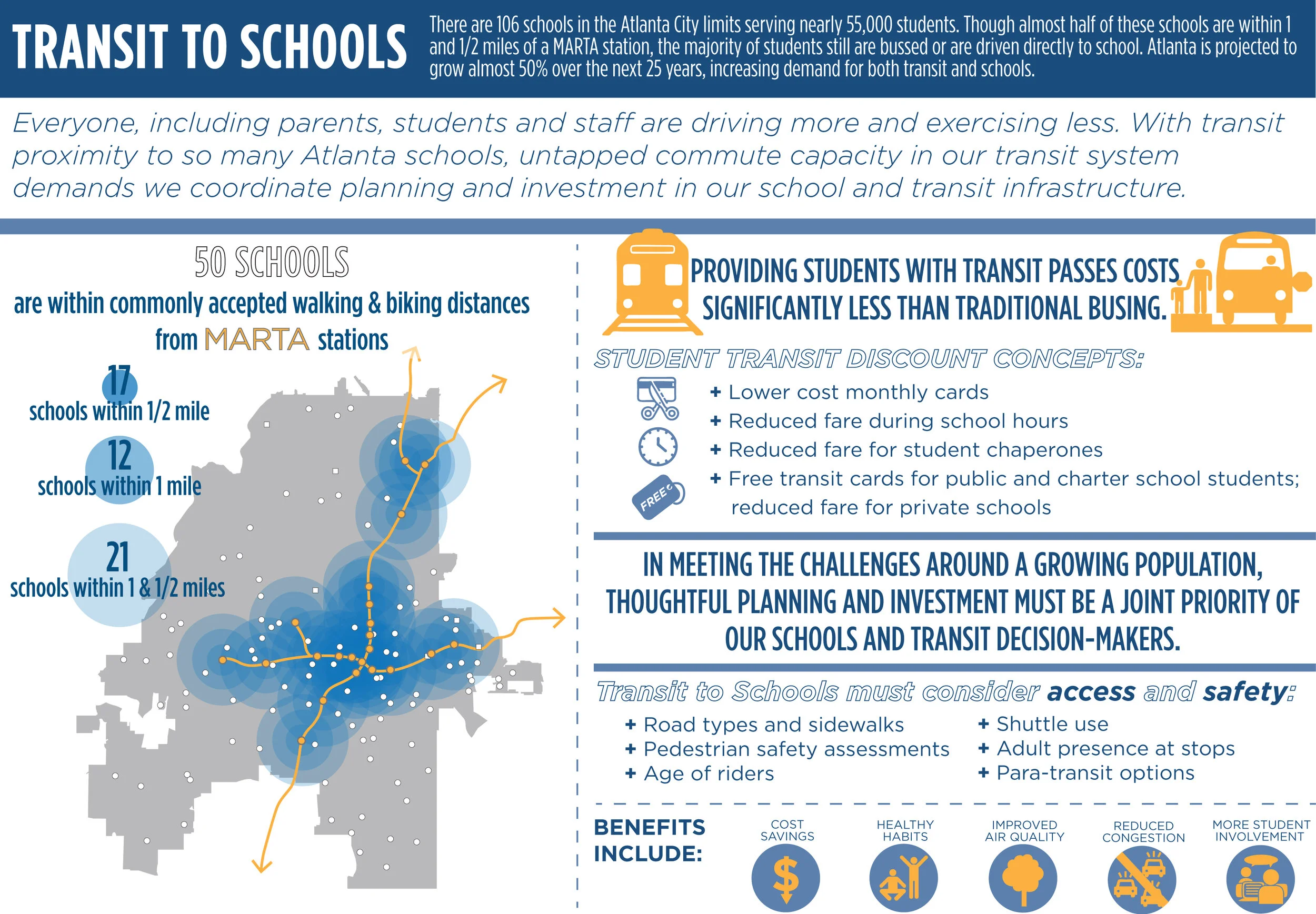
Transit investment is growing in Atlanta through the continued build out of the Beltline, MARTA transit-oriented developments, the extension of MARTA bus service to Clayton County and a potential north rail MARTA extension. These developments, along with the better use of existing infrastructure have the potential to positively impact school facility accessibility via transit. A meaningful portion (nearly 30% on school days) of traffic congestion can be attributed to the decisions that parents and students make about mode choice to school (aka, driving kids to school). Their decisions are, in turn, largely impacted by the siting and design of schools, a factor that drives facility accessibility, congestion around schools and ultimately impacts student health through increased pollution and less physical activity.
The intent of this semester-long workshop is to undertake case study research to identify national models that successfully integrate school access and active student mobility (non-vehicular) with transit investment and infrastructure coordination that are applicable to Atlanta.
The workshop, in partnership with Professor Richard Dagenhart and graduate students from Georgia Tech's College of Architecture, was organized as a weekly one-hour workshop with a primary focus on the relationship among existing and future public transit, public right of way connections, and school facilities across the city.
- Case Studies - Schools and Transit. This involves researching other efforts to identify programs initiated in other cities that connect schools to transit. The aim is to define issues and innovative program to better connect schools and transit.
- GIS Data Compiling and Mapping. This involves mining GIS data to map all schools in the City of Atlanta by type, all MARTA bus stops, and all current Atlanta Public Schools bus routes. The big question is this: How many schools can be currently accessed by public transit (or how many schools have a stop either at the school, within a quarter mile, or within a half mile, understanding distance not as a radius but as measured along public rights of way.)
- Existing Trip to School Data. This includes such information as existing school bus ridership, estimates of numbers of cars either driven to school or drop off, estimates of walking to school, and other relevant data.
- Schools and the Beltline. This will involve a projection into the future when Beltline transit is operating. Then the big question is to identify the potential of the Beltline and associated public transit to reshape K-12 education infrastructure.
The goal of this workshop is to enable school and transit planners to leverage respective investments that will allow them to create more active student commute options, while reducing Atlanta congestion (and pollution) through strategies to complete “last mile” walkable/bikable connections between schools and bus, rail, and trail points.
Click here to read Georgia Conservancy Senior Director of Sustainable Growth Kathrine Moore discuss schools and sprawl in a November 2016 issue of Saporta Report.
The final report Georgia Conservancy's Blueprints for Successful Communities School + Transit Design Studio will be available in Spring 2017.
Learn more about the Georgia Conservancy's work regarding school siting